Manuscripts
Journal of Journeys to Lyme Regis, Dorset
Image not available
You might also be interested in
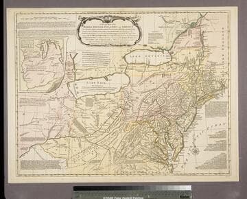
A general map of the middle British Colonies, in America : viz Virginia, Maryland, Delaware, Pensilvania, New-Jersey, New York, Connecticut & Rhode Island ; of Aquanishuonigy, the country of the Confederate Indians comprehending Aquanishuonigy proper, their places of residence, Ohio & Thuchsochruntie their deer-hunting countries, Couchsachrage and Skaniadarade, their beaver-hunting countries ; of the Lakes Erie, Ontario and Champlain ; wherein is also shewn the antient & present seats of the Indian Nations ; carefully copied from the original publish'd at Philadelphia / by Mr. Lewis Evans
Rare Books
Map 18216 is an anonymous copy printed about 1760. That plate has now been modified by the inclusion of a border around the title, the elimination of New France from the title and map face and the addition of John and Carinton Bowles names just below the title. This adds credence to Stevens' thought that 18216 is a proof copy, never issued until this plate was completed. Carington Bowles apparently succeeded his uncle Thomas Bowles in 1764 or 1765. Submap: A sketch of the Remaining part of the Ohio R., &c. MS note: 18218. Prime meridian: London, Philadelphia. Relief: pictorial. Graphic Scale: Miles. Projection: Pseudocylindrical. Printing Process: Copper engraving. Verso Text: Stamped: VII. MS notes: Shelve with #18212 Evans, Lewis ; #18218.
18218
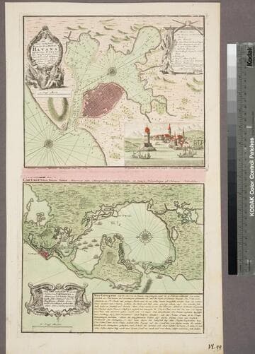
Neu und verbesserter Plan der St. u. Hafens Havana auf der Ins. Cuba mit den Wasser Tiefen, Sand haeneken und Klippen nochmahlen über Sohen y. Pr. Chassereau. Anno 1739. ; Neu und verbesserter Plan des Hafen von Carthagena in America, 16°26' Norder Breite, nach dem Entervurf des Pr. Chassereau, Archit. 1740. nach Engelland gebracht und ans Liechtgegeben
Visual Materials
Kashnor notes, "A Dutch issue of the plans published by Bowles in 1739-40, relating to Admiral Vernon's expedition." Printed with map of Cartagena on one sheet, that map dated 1740. See 105:383m for the English version this map is based on. Cartouche: wreath & figures. Vignette: Harbor of Havana. MS note: VL.49 (lower left). Relief: pictorial & hachures. Graphic Scale: Miles. Projection: Plane. Printing Process: Copper engraving. Other Features: CartoucheVignettes. Verso Text: MS note: 377.
105:377a ; 105:377b
Image not available
Thomas Cochran journal of a journey to Yo-Semite Valley
Manuscripts
Journal of a journey to Yosemite Valley and a voyage from San Francisco to the Isthmus of Panama aboard the ship Sacramento.
mssHM 52693
Image not available
Journal [of an overland journey to California by way of the Oregon and Lassen trails]
Manuscripts
The diary contains Bruff's descriptions of his overland journey across the plains in 1849 with the Washington City and California Mining Association and his activities in California after their arrival
mssHM 252
Image not available
Philetus W. Norris journals
Manuscripts
A manuscript originally bound in three volumes; volume I covers the years 1870 to 1875, volume II 1877 to 1878, and volume III 1876 to 1894. Volume I is made up of Norris' original printed letters to Michigan papers pasted down on paper sheets, with extensive additions, corrections, and notes; Norris was revising this material to publish in book form. Volume II contains another trip to the west in 1877 and volume III contains miscellaneous material which Norris intended to incorporate into his book. The volumes include interesting details and reports of the state of the west at that time, and also mention the battlefield of General George A. Custer and Yellowstone National Park; volume III contains an autograph map of the general area of the park, dated 1894. The pages were removed from the original damaged boards by the Huntington Conservation Department and placed in folders and three boxes; the original boards were retained and kept with the disbound material.
mssHM 506